How a sensor‑based art project in the Alps challenges the legal obsession with fixed demarcation, and what international law can learn from it.
Borders between Alpine states were fixed along watershed lines crossing glaciers, based on the premise that the ice was stable. However, these lines are now shifting at a rapid pace as glaciers retreat due to climate change. This therefore presents international law with a fundamental problem: what happens to a border when the physical geography on which it relies on no longer holds still?
Confini Mobili and the Limits of Fixed Borders
In 1970, a joint Italian-Austrian border commission documented tangible deviations between existing watershed lines and those mapped in 1923. The Florence-based Istituto Geografico Militare (IGM), responsible for demarcating Italy’s Alpine borders, responded by proposing the concept of confini mobili (“moving borders”). This concept indicates that borders would shift together with changes in the glacier itself rather than remain tied to outdated cartographic representations.
This approach was later formalised in Italian-Swiss agreements concluded in 2008. Instead of permanently fixing the boundary line, the agreements relied on periodic aerophotogrammetric surveys to update the border according to changes in the glacier. The legislation provided that “Il tracciato del confine sarà individuato sulla base di rilievi aerofotogrammetrici, e rimarrà in vigore fino ai rilievi successivi” (“the boundary line will be identified on the basis of aerophotogrammetric surveys and will remain in force until subsequent surveys”). Yet, this solution retained an older logic of demarcation, which is the assumption that unstable geography could still be periodically stabilised through maps and technical measurements. In practice, however, glaciers move too unpredictably and too rapidly for static, two-dimensional cartographic representation to fully capture their transformation.
The limitations of periodic re-surveying became the starting point for Italian Limes, a 2014 project that proposed a radically different approach. Instead of periodically redrawing the border, it aimed to allow the glacier to effectively “draw” the border itself. For international law, however, Italian Limes raises a broader challenge. In dynamic environments, the central problem of boundary-making may no longer be how to definitively demarcate borders, but how to administer them continuously. The project therefore exposes the limits of a legal tradition built around fixed territorial lines, stable cartographic representation, and the assumption that geography itself remains still.
These questions are increasingly visible elsewhere in international law. For more than a decade, the International Law Association’s Committee on International Law and Sea Level Rise has debated whether maritime baselines should retreat together with rising seas or remain legally fixed in order to preserve stability and legal certainty. Similar tensions are also present in debates on Arctic governance and its unstable ice environments, perpetually cycling between water and land. In both cases, the prevailing tendency has been to privilege legal stability over shifting geography. The Alpine case, and the Italian Limes in particular, move in the opposite direction. Rather than resisting environmental instability, they accept movement as the baseline condition and ask what kind of legal-technical apparatus might govern borders that are inherently dynamic.
The Italian Limes Project
Italian Limes (from the Latin limes: boundary, frontier, or limit) was launched in 2014 by Studio Folder, a visual research agency founded by Marco Ferrari and Elisa Pasqual. The project was designed not simply to document shifting Alpine borders, but to expose the instability underlying the modern assumption that borders can be permanently fixed through cartographic representation. In the words of its creators, the project “explores how natural borders—apparently unquestionable and self-evident—are in fact exposed to the complexity of long-term ecological processes, unveiling the problem of territorial representation and its political implications”.
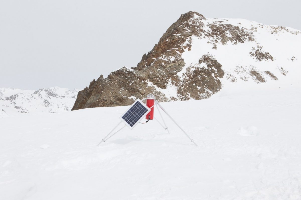
Rather than relying on periodic aerial surveys, Italian Limes installed a network of GPS sensors into the Grafferner glacier, straddling the watershed line marking the Italian-Austrian borders. The sensors continuously recorded the glacier’s movement and transmitted the data to an automated pantograph every two hours. The pantograph then redrew the watershed line on a scaled map according to the updated coordinates. The result was not a stable boundary representation, but a continuously shifting line. That is, a border permanently in the process of being redrawn.
A video demonstrating the operation of the pantograph
Source: https://vimeo.com/99248169
Three observations emerge from the Italian Limes project that are worth noting. First, the Alpine case illustrates the inherently interdisciplinary nature of border-making. The concept of “moving borders” did not originate in legal doctrine, but in the practical experience of geographers, cartographers, and engineers confronting the material instability of glaciers. International law has often treated borders as primarily legal constructs (for examples, see here and here), whereas the history of territorial disputes reveals deep dependence on technical disciplines and cartographic practices. Stephen B. Jones’s classic four-stage model of allocation, delimitation, demarcation, and administration itself originated in geography rather than law. As Jordan Branch has argued, the emergence of modern territorial borders was inseparable from a broader “cartographic revolution” in which maps became instruments for producing political authority rather than merely measuring and defining territory. International lawyers who overlook these technical and historical foundations risk mistaking a particular cartographic practice for a legal necessity.
Second, Italian Limes implicitly challenges the traditional ontological status of natural features in law by treating the glacier not as inert terrain but as an entity possessing a form of agency. In other words, an object with its own “personality.” Ice features (such as glaciers, icebergs, floes, and fast ice) and ice covered-areas, such as the those found in the Arctic, have been conceived by early geographers and historians as a featureless, immeasurable “negative geography” that defies any attempt of fixed bordering. International law seems to follow this imagination. Ice has typically been framed in instrumental terms, most clearly in Article 234 of UNCLOS, which conceptualises ice-covered areas primarily as navigational “hazards” requiring regulation, rather than as dynamic actors shaping spatial order.
Comparative jurisprudence is witnessing a rise of cases where natural features were granted legal personalities. In Lalit Miglani v State of Uttarakhand, the High Court of Uttarakhand (India) recognised the Himalayan glaciers of Gangotri and Yamunotri as legal persons, entitled to rights and protection. Although this decision was subsequently stayed by the Supreme Court of India, the suspension did not reject the underlying substantive arguments according to which certain natural features were granted legal subjectivity such as recognising glaciers as living entities with intrinsic rights and equating environmental harm to a personal harm. Rather, it rested on procedural concerns, such as enforceability, locus standi, and institutional capacity.
Third, both the “moving borders” framework and the logic of Italian Limes expose a structural limitation in classical demarcation practices, which is the assumption that a boundary, once identified, can be stabilised through periodic re-measurement. Even in its most technologically sophisticated form, demarcation remains tied to a temporal logic of fixing and updating, which presupposes that instability can be periodically captured and corrected. However, the pantograph’s output shows the limit of this assumption. Every map it draws is already outdated when produced.
These observations combined indicate a much deeper question. If demarcation is unviable from a technical point of view, does this lead us lawyers to give up territory altogether? My answer is no. Italian Limes’ key contribution lies neither in treating glaciers as “persons”, nor in the pantograph’s outdated maps, but rather in shifting the attention beyond demarcation and toward rethinking what borders fundamentally are.
International Law’s “Intellectual Abstraction” of Border-making
International law typically conceives boundary-making as a sequential process of allocation, delimitation, demarcation, and administration. In this framework, demarcation is understood as the moment at which legal uncertainty is resolved. A boundary is fixed in material space, translated into cartographic form, and thereby stabilised as legal fact.
Yet, the jurisprudence of boundary disputes suggests that this stabilisation is often more formal than real. The International Court of Justice’s judgment in Temple of Preah Vihear illustrates this tension clearly. The dispute concerned a treaty-defined watershed borderline between Cambodia and Thailand, alongside a later map (the “Annex I map”) that diverged from that topographical criterion. Rather than prioritising the physical watershed, the Court relied heavily on the cartographic representation and on Thailand’s subsequent acquiescence.
This judgement effectively displaced the geographical feature originally invoked by the treaty. As some judges noted in their separate opinions (Judge Wellington Koo, Sir Gerald Fitzmaurice, and Sir Percy Spender) that the decision privileged cartographic authority over technical geomorphological determination. Judge Moreno Quintana was particularly critical of treating the watershed as an “intellectual abstraction,” rather than a physical phenomenon requiring technical expertise to decide upon.
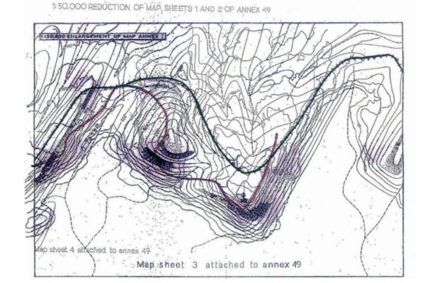
Map (ANNEX 1) used in Temple of Preah Vihear case showing the divergence between the watershed line (red) argued by Thailand, and the ‘map line’ (green) argued by Cambodia. The temple is marked with the double cross symbol.
Source: https://www.icj-cij.org/sites/default/files/case-related/151/17294.pdf
More fundamentally, this judicial preference reflects what has recently been described as “cartojuridism”. The constitutive relationship between legal authority and cartographic representation. Maps in this sense do not merely depict territory; they actively produce it as a statement of geographical fact, and as legally cognisable space. The “Annex I map” did not simply evidence the boundary. It came to define it.
Similarly, in their century‑long boundary disputes in the Andes, Argentina and Chile faced the same basic problem. Treaties assumed that mountain crests and watershed lines would coincide, but on the ground they often did not. In the 1902 arbitration, the tribunal avoided choosing between the two geographical criteria and simply imposed a compromise line, using the map as a tool of allocation rather than a record of geographic reality. In 1966, by contrast, the tribunal recognised a cartographic error in the original award and corrected the boundary to match the geography, which is the very opposite of what the ICJ did in Temple of Preah Vihear. Yet in the 1994 Laguna del Desierto case, the pendulum swung back. After appointing an expert to survey the watershed, the tribunal ultimately favoured a definitive legal allocation over the uncertainties of the terrain. Further indicating the tendency international law has is rather structural. When geography and cartography diverge, law privileges the map, making demarcation an intellectual stabilisation of space rather than a technical engagement with shifting terrain.
Toward Borders through Administration
Neither the “moving borders” practice, nor the Temple of Preah Vihear case, nor the century of Argentina–Chile boundary arbitrations resolve the deeper difficulty of demarcation in dynamic environments. Italian Limes instead points toward a different approach.
Borders, in international law, are not ends in themselves. Their function is to structure legal bounding of the subjects of sovereign states. Borders are instruments for differentiating between the internal and the external, the national and the foreign. Physical markers and fixed lines facilitate that distinction, but they are not its ultimate objective.
In my own work on territorialising the Arctic, I have argued that international law should resist patching unorthodox territorial situations with sui generis solutions, as the proliferation of exceptions could lead to a crisis of “extraordinary science” that in turn could threaten the very paradigm of territory in international law. Instead, I suggested a shift in emphasis toward mainstreaming “functional” ratione materiae borders. Administration understood as a primary and autonomous component of border-making, not merely as the maintenance of demarcation; boundaries drawn not by lines on a map but by the scope of legal powers exercised in a given space, recognised as a valid interest of a state by international law. Territory is therefore treated as the aggregate of all jurisdictional competences of a state, instead of a spatial/material concept.
I believe that Italian Limes pushes in the same direction. The project does not produce a better, more stable line, rather it produces a continuous process of legal-technical coordination that makes the boundary defined at any moment. That is, in effect, what a functional border looks like. That is, administered jurisdiction pegged to a reality that law can track, rather than to a fiction that nature will eventually erase.
Alaa Assaf is an Adjunct Lecturer at the Faculty of Law at the University of Kalamoon, Syria. His research interests include the critical analysis of territorial sovereignty and non‑spatial political domains in international law.